Stay updated on impending weather warnings that may affect travel throughout the UK.
The UK is preparing for severe weather as weather warnings have been issued for heavy rain and strong winds. These alerts primarily affect regions in Wales and the south-west of England. The Met Office has announced a yellow warning for high winds, in effect from Monday night through Tuesday afternoon, signaling potential disruptions to transportation networks.
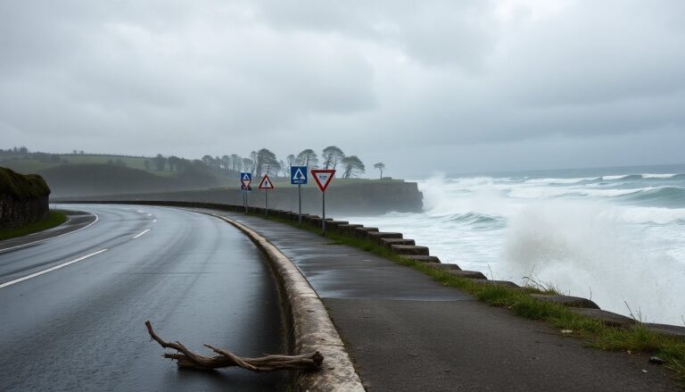
Delays are expected for high-sided vehicles on exposed routes, particularly on bridges. Coastal roads and seafronts may face rough conditions due to large waves and spray. Travelers should remain vigilant as they plan their journeys amidst this unsettled weather.
Upcoming weather forecasts and warnings
The Met Office forecasts a yellow warning for rain across a broader area, extending to Hampshire and Oxfordshire. This warning is set to last from Monday evening until Tuesday evening, with significant flooding risks affecting homes and businesses.
Some communities may find themselves isolated due to rising waters.
Impact on travel and infrastructure
In addition to rain warnings, another alert is in effect for north-west England from midnight on Tuesday until the afternoon. Strong winds are also expected in north-west Scotland from Tuesday afternoon through Wednesday morning. The Met Office warns that fast-flowing or deep floodwaters pose a serious risk to life, stressing the need to stay updated on weather developments.
These forecasts follow a previous yellow warning for heavy rain in Northern Ireland, highlighting the widespread nature of the impending weather. As of early Monday, twelve flood warnings were already active across England, indicating the seriousness of the situation.
Recent weather conditions and their effects
Parts of the south coast experienced gusts of up to 40 mph over the weekend, causing incidents such as detached garage roofs in Seaford, East Sussex. Dan Holley, the deputy chief meteorologist, noted the uncertainty regarding the exact path and intensity of the incoming low-pressure system, but it is expected to bring rain that could worsen flooding in already saturated areas.
Looking ahead: December’s weather outlook
As December progresses, the forecast remains unstable, with more low-pressure systems anticipated. Meteorologists have indicated that clarity regarding Christmas weather predictions is still lacking, as current patterns suggest continued unsettled conditions.
In North Wales, another deluge is expected for the upcoming weekend, with the Met Office characterizing the weather pattern as a temporary pause in winter. Following a brief cold snap, the region is likely to face further wet and windy weather as a low-pressure system approaches.
Rainfall totals could be significant, especially in highland areas, with predictions of 30 to 40 mm of rain in South Wales and even higher totals in North Wales and Scotland. The Met Office warns these regions are particularly vulnerable to heavy rainfall over the weekend.
The current jet stream configuration, oriented north-south to the east of the UK, is contributing to these unstable weather patterns. As the system shifts southward, it is likely to bring more intense low-pressure systems, resulting in heavy rainfall events.
Delays are expected for high-sided vehicles on exposed routes, particularly on bridges. Coastal roads and seafronts may face rough conditions due to large waves and spray. Travelers should remain vigilant as they plan their journeys amidst this unsettled weather.0
